Category Archives: Fleet Management and Vehicle Security Control System

GIS (geographic information system)

earthquake_map_lg

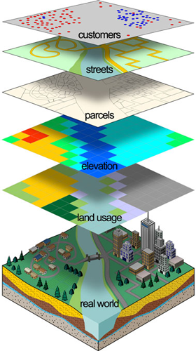
A geographic information system (GIS) is a computer system for capturing, storing, checking, and displaying data related to positions on Earth’s surface. GIS can show many different kinds of data on one map. This enables people to more easily see, analyze, and understand patterns and relationships.

With GIS technology, people can compare the locations of different things in order to discover how they relate to each other. For example, using GIS, the same map could include sites that produce pollution, such as gas stations, and sites that are sensitive to pollution, such as wetlands. Such a map would help people determine which wetlands are most at risk.

GIS can use any information that includes location. The location can be expressed in many different ways, such as latitude and longitude, address, or ZIP code. Many different types of information can be compared and contrasted using GIS. The system can include data about people, such as population, income, or education level. It can include information about the land, such as the location of streams, different kinds of vegetation, and different kinds of soil. It can include information about the sites of factories, farms, and schools, or storm drains, roads, and electric power lines.

Data and GIS

Data in many different forms can be entered into GIS. Data that are already in map form can be included in GIS. This includes such information as the location of rivers and roads, hills and valleys. Digital, or computerized, data can also be entered into GIS. An example of this kind of information is data collected by satellites that show land use—the location of farms, towns, or forests. GIS can also include data in table form, such as population information. GIS technology allows all these different types of information, no matter their source or original format, to be overlaid on top of one another on a single map.

Putting information into GIS is called data capture. Data that are already in digital form, such as images taken by satellites and most tables, can simply be uploaded into GIS. Maps must be scanned, or converted into digital information.

GIS must make the information from all the various maps and sources align, so they fit together. One reason this is necessary is because maps have different scales. A scale is the relationship between the distance on a map and the actual distance on Earth. GIS combines the information from different sources in such a way that it all has the same scale.

Often, GIS must also manipulate the data because different maps have different projections. A projection is the method of transferring information from Earth’s curved surface to a flat piece of paper or computer screen. No projection can copy the reality of Earth’s curved surface perfectly. Different types of projections accomplish this task in different ways, but all result in some distortion. To transfer a curved, three-dimensional shape onto a flat surface inevitably requires stretching some parts and squeezing other parts. A world map can show either the correct sizes of countries or their correct shapes, but it can’t do both. GIS takes data from maps that were made using different projections and combines them so all the information can be displayed using one common projection.

gis_layers

GIS Maps

Once all of the desired data have been entered into a GIS system, they can be combined to produce a wide variety of individual maps, depending on which data layers are included. For instance, using GIS technology, many kinds of information can be shown about a single city. Maps can be produced that relate such information as average income, book sales, and voting patterns. Any GIS data layer can be added or subtracted to the same map.

GIS maps can be used to show information about number and density. For example, GIS can be used to show how many doctors there are in different areas compared with the population. They can also show what is near what, such as which homes and businesses are in areas prone to flooding.

With GIS technology, researchers can also look at change over time. They can use satellite data to study topics such as how much of the polar regions is covered in ice. A police department can study changes in crime data to help determine where to assign officers.

GIS often contains a large variety of data that do not appear in an onscreen or printed map. GIS technology sometimes allows users to access this information. A person can point to a spot on a computerized map to find other information stored in the GIS about that location. For example, a user might click on a school to find how many students are enrolled, how many students there are per teacher, or what sports facilities the school has.

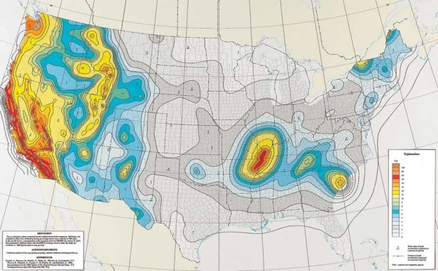
GIS systems are often used to produce three-dimensional images. This is useful, for example, to geologists studying faults.

GIS technology makes updating maps much easier. Updated data can simply be added to the existing GIS program. A new map can then be printed or displayed on screen. This skips the traditional process of drawing a map, which can be time-consuming and expensive.

People working in many different fields use GIS technology. Many businesses use GIS to help them determine where to locate a new store. Biologists use GIS to track animal migration patterns. City officials use GIS to help plan their response in the case of a natural disaster such as an earthquake or hurricane. GIS maps can show these officials what neighborhoods are most in danger, where to locate shelters, and what routes people should take to reach safety. Scientists use GIS to compare population growth to resources such as drinking water, or to try to determine a region’s future needs for public services like parking, roads, and electricity. There is no limit to the kind of information that can be analyzed using GIS technology.

GPS(Global Positioning System)

gps_satellite_nasa

What is GPS?

How it works

GPS satellites circle the earth twice a day in a very precise orbit and transmit signal information to earth. GPS receivers take this information and use triangulation to calculate the user’s exact location. Essentially, the GPS receiver compares the time a signal was transmitted by a satellite with the time it was received. The time difference tells the GPS receiver how far away the satellite is. Now, with distance measurements from a few more satellites, the receiver can determine the user’s position and display it on the unit’s electronic map.

gpsscreens2

A GPS receiver must be locked on to the signal of at least three satellites to calculate a 2D position (latitude and longitude) and track movement. With four or more satellites in view, the receiver can determine the user’s 3D position (latitude, longitude and altitude). Once the user’s position has been determined, the GPS unit can calculate other information, such as speed, bearing, track, trip distance, distance to destination, sunrise and sunset time and more.

How accurate is GPS?

Today’s GPS receivers are extremely accurate, thanks to their parallel multi-channel design. Garmin’s 12 parallel channel receivers are quick to lock onto satellites when first turned on and they maintain strong locks, even in dense foliage or urban settings with tall buildings. Certain atmospheric factors and other sources of error can affect the accuracy of GPS receivers. Garmin® GPS receivers are accurate to within 15 meters on average.

dgpsworks

Newer Garmin GPS receivers with WAAS (Wide Area Augmentation System) capability can improve accuracy to less than three meters on average. No additional equipment or fees are required to take advantage of WAAS. Users can also get better accuracy with Differential GPS (DGPS), which corrects GPS signals to within an average of three to five meters. The U.S. Coast Guard operates the most common DGPS correction service. This system consists of a network of towers that receive GPS signals and transmit a corrected signal by beacon transmitters. In order to get the corrected signal, users must have a differential beacon receiver and beacon antenna in addition to their GPS.

24satellite

The GPS satellite system

The 24 satellites that make up the GPS space segment are orbiting the earth about 12,000 miles above us. They are constantly moving, making two complete orbits in less than 24 hours. These satellites are travelling at speeds of roughly 7,000 miles an hour.

GPS satellites are powered by solar energy. They have backup batteries onboard to keep them running in the event of a solar eclipse, when there’s no solar power. Small rocket boosters on each satellite keep them flying in the correct path.

Here are some other interesting facts about the GPS satellites (also called NAVSTAR, the official U.S. Department of Defense name for GPS):

  • The first GPS satellite was launched in 1978.
  • A full constellation of 24 satellites was achieved in 1994.
  • Each satellite is built to last about 10 years. Replacements are constantly being built and launched into orbit.
  • A GPS satellite weighs approximately 2,000 pounds and is about 17 feet across with the solar panels extended.
  • Transmitter power is only 50 watts or less.

What’s the signal?

GPS satellites transmit two low power radio signals, designated L1 and L2. Civilian GPS uses the L1 frequency of 1575.42 MHz in the UHF band. The signals travel by line of sight, meaning they will pass through clouds, glass and plastic but will not go through most solid objects such as buildings and mountains.

A GPS signal contains three different bits of information – a pseudorandom code, ephemeris data and almanac data. The pseudorandom code is simply an I.D. code that identifies which satellite is transmitting information. You can view this number on your Garmin GPS unit’s satellite page, as it identifies which satellites it’s receiving.

Ephemeris data, which is constantly transmitted by each satellite, contains important information about the status of the satellite (healthy or unhealthy), current date and time. This part of the signal is essential for determining a position.

The almanac data tells the GPS receiver where each GPS satellite should be at any time throughout the day. Each satellite transmits almanac data showing the orbital information for that satellite and for every other satellite in the system.

blockedsignal

Sources of GPS signal errors

Factors that can degrade the GPS signal and thus affect accuracy include the following:

  • Ionosphere and troposphere delays – The satellite signal slows as it passes through the atmosphere. The GPS system uses a built-in model that calculates an average amount of delay to partially correct for this type of error.
  • Signal multipath – This occurs when the GPS signal is reflected off objects such as tall buildings or large rock surfaces before it reaches the receiver. This increases the travel time of the signal, thereby causing errors.
  • Receiver clock errors – A receiver’s built-in clock is not as accurate as the atomic clocks onboard the GPS satellites. Therefore, it may have very slight timing errors.
  • Orbital errors – Also known as ephemeris errors, these are inaccuracies of the satellite’s reported location.
  • Number of satellites visible – The more satellites a GPS receiver can “see,” the better the accuracy. Buildings, terrain, electronic interference, or sometimes even dense foliage can block signal reception, causing position errors or possibly no position reading at all. GPS units typically will not work indoors, underwater or underground.
  • Satellite geometry/shading – This refers to the relative position of the satellites at any given time. Ideal satellite geometry exists when the satellites are located at wide angles relative to each other. Poor geometry results when the satellites are located in a line or in a tight grouping.
  • Intentional degradation of the satellite signal – Selective Availability (SA) is an intentional degradation of the signal once imposed by the U.S. Department of Defense. SA was intended to prevent military adversaries from using the highly accurate GPS signals. The government turned off SA in May 2000, which significantly improved the accuracy of civilian GPS receivers.

Automatic Vehicle Location(AVL) … “Black Box”

avl

Automatic Vehicle Location…(AVL)

…“Black Box”

Automatic Vehicle Location (AVL) ‘black box’ allows businesses to track their vehicles
through the use of such technologies as global positioning system (GPS) tracking.
AVL, along with other mobile data technology, such as electronic proof of delivery, is
all about closing the “black hole” that often exists beyond goods out. GPS tracking
provides high levels of visibility relating to vehicle security, schedule adherence, route
adherence and driver performance – which in turn contributes to:

  • Increased productivity – reduced leg times, reduced drop times, reduced mileage,
    more scope for back-hauls and adhoc collections, more productive output from
    drivers for the same paid hours
  • Reduced fuel consumption – through accurate control of routes, reduced excessive
    idle and improved driving style
  • Increased security – minimised deviation from route and unscheduled stops.
    Particularly effective where tracking is coupled with door sensors and wireless
    panic buttons
  • Reduced night out / stop over claims and expenses
  • Improved customer service – through improved planning and
    pre-arrival / lateness warnings
  • Fleet rationalisation – a key by-product of improved productivity

Business Benefits

With these improvements in mind, the sort of business benefits the implementation of
AVL has delivered to Opus Fleet & Distribution customers, through increased driver
and vehicle visibility and control, include:

  • Delivery time reduced from 40 mins to 25 mins
  • 30% reduction in night outs / stop overs
  • An average of 2.2 hours out of 10 hour shift identified as excessive idling
  • Between 7% & 14% reduction in fuel consumption. (In the former instance, this was
    achieved in the first 8 weeks of the project – forecast as a £900,000 saving in first
    year across a 900 vehicle eet)
  • 30% productivity improvement in the transport process – through the compression
    of turn around times, leg times and more drops per vehicle per day through better
    visibility leading to better fixed route planning
  • Route adherence – projected saving of approximately 2.7 million miles of road usage
    by vehicles (for the period of the 5 year contract)
  • Security – reduction to 0% delivery shrinkage in 3 months
  • Improved customer service with greater visibility of the supply chain allowing
    queries to be answered promptly with up to date information. 85% reduction in
    lead time to answer queries
  • A 6% reduction in eet size (4 out of 62 vehicles)

AVL Unit – Key Features

  • Local business rule-based control and monitoring; remote updates of rule-sets supported
  • GPRS, GSM (or Mobitex) communications
  • “Soft” telematics (over speed, harsh braking, excessive idling, unscheduled stops etc)
  • CANBus/FMS interface supporting “hard” telematics – used to capture and filter vehicle telematics data such as revs (up to 32 parameters can be monitored)
  • Dallas key interface – for driver, vehicle and even trailer identification
  • Temperature monitoring (up to 8 sensors)
  • 4 port serial switch – up to 4 peripherals can be connected and controlled (mobile data
    terminals, printers, etc)
  • Battery and solar panel back-up options
  • Wireless panic buttons-when pressed an alert and the last known location is sent back to the control center monitoring the vehicle
  • Analogue module – optional device that captures revs on non-CANBus vehicles
  • Optional “privacy switch” for owner-driver type vehicles

banner01

Functional Summary

The AVL unit provides integral GPRS/GSM communications, GPS Satellite location and
“business rule” controls. A variety of inputs, outputs and other vehicle monitoring capabilities are catered for. Business rules determine how often the vehicle is tracked and how certain  events are evaluated by the AVL unit.

These rules can be as simple as ‘tell me when you have arrived at/departed from a site’, ‘are the doors open when they should not be’, ‘tell me when  you have been stationary with the engine running for more than so many minutes’, ‘tell me  when you have deviated from a planned route or ‘tell me when you have made an unexpected stop’.

Rules and conditions can be mixed and matched with ease. Rule sets are downloaded to
vehicles over air. Different rule sets can be allocated to vehicle groups or types.
Inputs on the AVL unit can monitor doors, ignition, temperature, wireless panic buttons and
more. Outputs can control, for example, door locks, screamers and indicators.
Vehicle telematics are also supported, both in ‘soft’ and ‘hard’ formats.

Soft refers to the ability  to monitor over-speed, harsh braking and idling without connecting to the vehicle or engine.
Hard telematics are supported via a CANBus connection with FMS support, allowing
monitoring of up to 32 vehicle and engine parameters, from revs to service indicators and
more.
AVL GPRS tracking solutions have been fitted to vehicles working on Pan-European routes
covering 14 main-land European countries (a list which is growing all the time).
All of the Opus Fleet & Distribution portfolio is modular – mobile data terminals (for proof of
delivery applications) are also supported, using the Black Box’s built-in communications to
send and receive data from the host.
Tracking data is displayed via street level mapping in the Transport Management Center which allows the business to monitor, in real-time, delivery progress against plan.
The AVL tracking solution also comes with over 20 standard web-based reports and customers also have the option to develop their own custom reports.

GPRS: General Packet Radio Service

General Packet Radio Service (GPRS) is a packet-data technology that allows GSM operators to launch wireless data services, such as e-mail and Internet access. As a result, GPRS provides operators with the ability to use data to drive additional revenue. GPRS is often called a 2.5G technology because it is a GSM operator’s first step toward third generation (3G) and a first step in wireless data services.

gprs

Although GPRS is a data-only technology, it helps improve GSM voice capacity. When an operator deploys GPRS, it also can upgrade to a vocoder, a new type of voice coder that turns voice into digital signals before they pass across the wireless network. The vocoder uses Adaptive Multi-rate speech transcoding (AMR) technology, which can handle twice as many simultaneous voice calls as a network that uses the old vocoder. As a result, GPRS allows GSM operators to accommodate additional voice traffic without the expense of acquiring additional spectrum.
GPRS supports peak download data rates of up to 115 kbps, with average speeds of 40 to 50 kbps, which is comparable to other 2.5G technologies, such as CDMA2000 1x. GPRS speeds are fast enough for applications such as Multimedia Messaging Service (MMS) and a web browsing experience comparable to a wired dial-up modem. GPRS also allows customers to maintain a data session while answering a phone call, which is a unique and exclusive feature to GSM. GPRS also provides an always-on data connection, so users do not have to log on each time they want data access. The packet architecture also means that users pay only for the data itself rather than for the airtime used to establish a connection and download data.
GPRS is the most widely supported packet-data wireless technology in the world. Like GSM, GPRS supports international roaming so customers can access data services whether they are at home or abroad. When users travel to areas that have not yet been upgraded to GPRS, they still can access many data services via circuit-switched GSM.
The significant global operator and user adoption of GPRS has created a customer base that has attracted dozens of device manufacturers. As a result, thousands of models of GPRS phones and PC card modems are currently available. In fact, virtually all GSM model devices have GPRS.
GPRS builds on the GSM network platform, so operators can leverage their existing infrastructure, such as base stations and Mobile Switching Centers (MSCs). The GPRS core network is based on Internet Protocol (IP) standards, which make it ideal for providing wireless access to other IP-based networks, such as Internet Service Providers (ISPs) and corporate Local Area Networks (LANs). The GPRS core also serves as the foundation for all subsequent steps toward 3G. For example, when operators deploy EDGE and UMTS-HSPA, they reuse GPRS core elements such as Gateway GPRS Support Nodes (GGSNs); this design ensures that each step in the migration to 3G is smooth and cost-effective.